10 The Israelites moved on and camped at Oboth.
11 Then they set out from Oboth and camped in Iye Abarim, in the wilderness that faces Moab toward the sunrise.
12 From there they moved on and camped in the Zered Valley.
13 They set out from there and camped alongside the Arnon, which is in the wilderness extending into Amorite territory. The Arnon is the border of Moab, between Moab and the Amorites. Then they went from the wilderness to Mattanah,
19 from Mattanah to Nahaliel, from Nahaliel to Bamoth,
20 and from Bamoth to the valley in Moab where the top of Pisgah overlooks the wasteland. (See Numbers 21 for additional info about what they did when they got there.)
These wandering Israelites are about to reach the promised land. Our 60 day trek has brought us 90 more miles to Ashland VA - just north of Richmond if you are looking for it on the map. We intend to get to Yorktown on Monday after experiencing some more historical sites along the way.
 |
| Tom had his standards |
More bike problems. Phil's bike had a flat hanging off the back of the car. (?) Pete's bike had another broken spoke and tire out of round. He had to disengage his back brake so the wheel would go around. He rode that way for about 40 miles to Ashland and a bike shop. All fixed.
The state of Virginia has taken our route (published by Adventure Cycling) and created road signs guiding us through the State. It has also drawn the route on the official state map and on the scenic map of the state. The signs have been very helpful in preventing us from taking the wrong road.
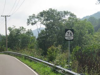 |
| These signs guide us along our route through VA. |
|
 |
The top sign has a special meaning to the Zaruba family in CO Springs
The second one is for cat lovers. |


No comments:
Post a Comment